

| Location, Maps and Access to Liville Gorge | |||||
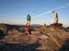
Linville Gorge is considered the "Grand Canyon of the East"! It is a deep Gorge with cliffs and thick forest. And of course, the Liville River running down the center. The Gorge has the designate of Wilderness area, meaning that there is no human "impact", just the wilderness as it was. Therefore, no trails have blazes; there is "supposedly" no trail maintenance; etc... The Gorge is located East of the Black Mountains (Mt. Mitchell) and Southwest of Grandfather Mountain. Directly to the Gorge's East is the Wilson Creek area. Specifically, Linville Gorge is bordered as follows:
|
|||||
| Informational External Links for Linville Gorge | ||
| Local weather (Accuweather) | Local weather (Rays Weather Center) | |
| LinvilleGorge.net | LinvilleGorge.net GPS waypoint map (google) | |
| LinvilleGorge.net GPS waypoint map (jpg) | Official Gorge pamphlet with trails | |
| Documentation: Galleries featuring Linville Gorge | ||||||||||
 11/26/09 - 11/28/09 Spence Ridge |
 3/26/10 - 3/27/10 Spence Ridge |
 4/2/10 - 4/3/10 Little Table Rock |
 10/08/10 - 10/09/10 Little Table |
 11/12/10 - 11/13/10 Hawksbill |
Chimneys Site | |||||